Beobachtungen
Observations:
Psi-Track-009, Verfolgen einer Spur, Orientierung,
Fortsetzung
Pursuing of a trace,
orientation, continuation
zum Verteiler Psi-Track und zu den anderen Psi-Track-Seiten psi-track-000
back
to
the main page of psi track
Drei dem "Sender" persönlich bekannte Ziele, jeweils Gebäude in größerer Entfernung, wurden ausgewählt:
in der Toscana Entfernung 913 km , in Kiel 288 km und in Köln 253 km.
Three
personally well known targets, in each case buildings at larger
distance, were choosen.
Von zwei unterschiedlichen Standorten aus wurden die Richtungen gesucht.
Die gefundenen Spuren zeigen Abweichungen zur Luftlinie von etwa bis 15 zu Grad.
Bei der Richtung Kiel gab es am ersten Standort zwei Spuren, eine schwache Spur und eine etwas stärkere.
Beide Spuren liegen jeweils links und rechts etwa den gleichen Differenzwinkel von der Luftlinie entfernt.
Offensichtlich war hier das Gelände etwas gestört, d.h. nicht frei von weiteren Einflüssen.
From two
different locations the directions were looked for.
The found traces have deviations from the direction line approximately to 15 to degrees.
With the direction Kiel two traces were found at the first location, a weak trace and a something more stronger.
Both traces were symmetrical arranged on both sides of the direction line with almost the same difference angle.
Obviously the area was here somewhat disturbed, i.e. not free of further influences.
Standort 1:
http://maps.live.de/LiveSearch.LocalLive?
interaktives Luftbild GoogleEarth aerial photography
psi-track-009a-a.kmz
Standort 2:
http://maps.live.de/LiveSearch.LocalLive?
interaktives Lufbild Google Earth
psi-track-009b.kmz
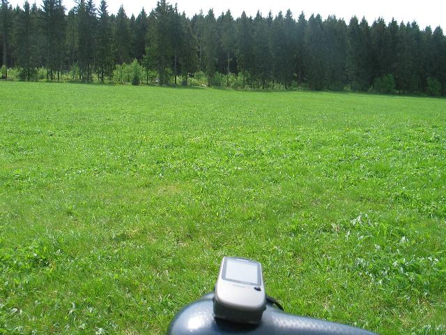
Alle Beobachtungen erfolgten nach der natürlichen Methode, d.h. ohne Hilfsmittel wie eine Rute.
Die Koordinaten der gefundenen Positionen wurden nachvollziehbar per GPS mit Datum und Uhrzeit protokolliert.
All
observations were done by the natural method, i.e. without aids like a
rod. The coordinates of the found positions and the walked tracks were
logged replicable by GPS with date and time.
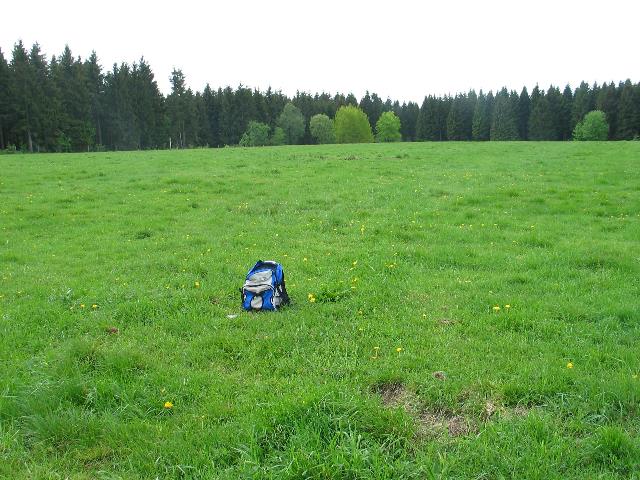 |
| Abb. 01: Standort 1. Das
Ziel Toscana liegt
in dieser Richtung. Location 1, view toward the target Toscana. (FB) |
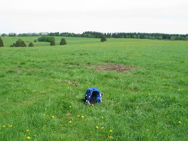 |
| Abb. 02: Standort 1. Das
Ziel Kiel liegt in
dieser Richtung. Location 1, view to the target Kiel (FB) |
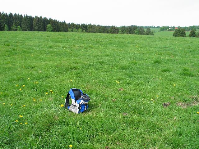 |
| Abb. 03: Standort 1.
Das Ziel Köln
liegt in dieser Richtung. Location 1, view to the target Koeln. (FB) |
 |
| Abb. 04: Standort 1. Die
gefundenen Spuren
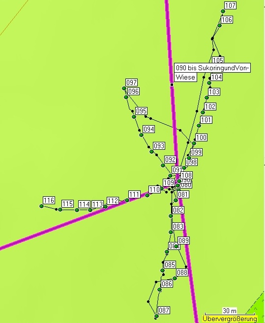
und die drei Luftlinien. oben: Kiel, links: Köln, unten: Toscana schwarz: gelaufener Weg, grün: markierte Punkte Bei der Spurensuche in Richtung Kiel gab es eine stärkere zweite ab Punkt 98 Location 1, found traces and three direction lines: above Kiel, left koeln, down Toscana black: track, green: marked points, With the direction Kiel there are two traces. The most stronger trace starts at point 098 (FB) |
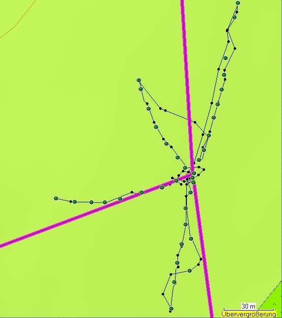 |
| Abb. 05: Standort 1. Die
gleichen Spuren ohne Markierungstexte,
bei der unteren (Toscana) wurden auf dem Rückweg zwei weitere
Markierungen gesetzt (088 und 089). Bei der Spur rechts oben wurde vor den letzten beiden Punkte ein Zick-Zack-Suchweg beschritten. Location 1, same data, but without text, With the trace to Toscana the track there are two additional points on the way back (088 and 089) In the upper right picture corner a zig-zag way was gone. (105 106) (FB) |
 |
| Abb. 06: Standort 2. Das
Ziel Kiel liegt in
dieser Richtung. Location 2, view toward the target Kiel (FB) |
 |
| Abb. 07: Standort 2. Das Ziel
Köln
liegt in dieser Richtung. Location 2, view toward the target Koeln (FB) |
 |
| Abb. 08: Standort 2. Das
Ziel Toscana liegt
in dieser Richtung. Location 2, view toward the target Toscana (FB) |
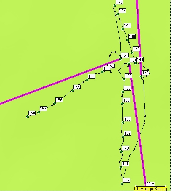 |
| Abb. 09: Standort 2. Die
gefundenen Spuren. Am Anfang jeder Spur (Punkt 134, 143 und 151) ist durch die schwarzen Markierungen deutlich der Kreisbogen zum Suchen der Spur protokolliert worden. Location 2, found traces. With beginning of each trace the tracks show an arch (semicircle) starting from the "sending" point. (FB) |
| Standort
1 Location 1 Liste der markierten Punkte, Aufteilung nach einzelnen Abschnitten Gesamt Dauer 14 Minuten, Informationen zu den GPS-Daten: geologie-001 elapsed time 14 minutes markierte Positionen der Spuren Name, Datum Uhrzeit, Koordinate Geländehöhe/Luftdruck Toscana 080 09-MAI-09 11:05:06 N51 47 18.3 E10 21 31.9 561 m 081 09-MAI-09 11:05:37 N51 47 18.1 E10 21 31.8 565 m 082 09-MAI-09 11:05:48 N51 47 17.8 E10 21 31.6 566 m 083 09-MAI-09 11:05:57 N51 47 17.5 E10 21 31.6 566 m 084 09-MAI-09 11:06:10 N51 47 17.1 E10 21 31.5 565 m 085 09-MAI-09 11:06:19 N51 47 16.7 E10 21 31.4 565 m 086 09-MAI-09 11:06:28 N51 47 16.3 E10 21 31.3 564 m 087 09-MAI-09 11:06:43 N51 47 15.8 E10 21 31.2 566 m 088 09-MAI-09 11:07:25 N51 47 16.6 E10 21 31.8 567 m 089 09-MAI-09 11:07:46 N51 47 17.2 E10 21 31.8 566 m 090 09-MAI-09 11:10:24 N51 47 18.4 E10 21 31.9 570 m Kiel-1 091 09-MAI-09 11:11:00 N51 47 18.6 E10 21 31.6 571 m 092 09-MAI-09 11:11:10 N51 47 18.8 E10 21 31.4 569 m 093 09-MAI-09 11:11:19 N51 47 19.1 E10 21 31.0 569 m 094 09-MAI-09 11:11:29 N51 47 19.4 E10 21 30.7 569 m 095 09-MAI-09 11:11:39 N51 47 19.8 E10 21 30.5 569 m 096 09-MAI-09 11:11:50 N51 47 20.1 E10 21 30.2 567 m 097 09-MAI-09 11:11:55 N51 47 20.3 E10 21 30.2 567 m Kiel-2 098 09-MAI-09 11:13:10 N51 47 18.7 E10 21 32.1 571 m 099 09-MAI-09 11:13:18 N51 47 18.9 E10 21 32.2 572 m 100 09-MAI-09 11:13:27 N51 47 19.2 E10 21 32.4 572 m 101 09-MAI-09 11:13:36 N51 47 19.6 E10 21 32.5 571 m 102 09-MAI-09 11:13:43 N51 47 19.8 E10 21 32.7 572 m 103 09-MAI-09 11:13:51 N51 47 20.1 E10 21 32.8 572 m 104 09-MAI-09 11:13:59 N51 47 20.4 E10 21 32.9 572 m 105 09-MAI-09 11:14:08 N51 47 20.8 E10 21 32.9 572 m 106 09-MAI-09 11:14:36 N51 47 21.6 E10 21 33.2 571 m 107 09-MAI-09 11:14:45 N51 47 21.8 E10 21 33.3 570 m Köln 108 09-MAI-09 11:16:48 N51 47 18.5 E10 21 31.9 575 m 109 09-MAI-09 11:17:51 N51 47 18.3 E10 21 31.3 573 m 110 09-MAI-09 11:18:05 N51 47 18.2 E10 21 30.9 573 m 111 09-MAI-09 11:18:16 N51 47 18.1 E10 21 30.3 573 m 112 09-MAI-09 11:18:28 N51 47 18.0 E10 21 29.6 574 m 113 09-MAI-09 11:18:38 N51 47 17.9 E10 21 29.1 575 m 114 09-MAI-09 11:18:45 N51 47 17.9 E10 21 28.6 575 m 115 09-MAI-09 11:18:53 N51 47 17.9 E10 21 28.1 574 m 116 09-MAI-09 11:19:05 N51 47 18.0 E10 21 27.5 575 m Koordinaten der Ziele Köln N50 56 25.8 E6 57 30.5 46 m Toscana N43 37 53.3 E11 53 10.2 Kiel N54 21 40.7 E10 04 56.3 19 m |
| Tabelle 01: Markierte Positionen
am Standort 1 (FB) |
Standort 2 Location 2 Toscana 134 09-MAI-09 11:33:58 N51 46 39.0 E10 20 22.4 541 m 135 09-MAI-09 11:35:18 N51 46 38.7 E10 20 22.2 543 m 136 09-MAI-09 11:35:33 N51 46 38.4 E10 20 22.1 543 m 137 09-MAI-09 11:35:44 N51 46 38.2 E10 20 22.1 544 m 138 09-MAI-09 11:35:53 N51 46 37.8 E10 20 22.2 544 m 139 09-MAI-09 11:36:03 N51 46 37.5 E10 20 22.2 545 m 140 09-MAI-09 11:36:12 N51 46 37.1 E10 20 22.1 546 m 141 09-MAI-09 11:36:21 N51 46 36.8 E10 20 22.1 545 m 142 09-MAI-09 11:36:32 N51 46 36.4 E10 20 22.1 545 m Kiel 143 09-MAI-09 11:37:41 N51 46 38.8 E10 20 22.8 542 m 144 09-MAI-09 11:38:50 N51 46 39.1 E10 20 22.6 542 m 145 09-MAI-09 11:39:00 N51 46 39.3 E10 20 22.5 542 m 146 09-MAI-09 11:39:10 N51 46 39.6 E10 20 22.3 541 m 147 09-MAI-09 11:39:17 N51 46 39.8 E10 20 22.1 541 m 148 09-MAI-09 11:39:26 N51 46 40.1 E10 20 22.0 541 m 149 09-MAI-09 11:39:32 N51 46 40.3 E10 20 21.9 540 m 150 09-MAI-09 11:40:08 N51 46 39.1 E10 20 22.1 543 m Köln 151 09-MAI-09 11:40:50 N51 46 39.2 E10 20 22.1 543 m 152 09-MAI-09 11:41:47 N51 46 38.9 E10 20 21.6 542 m 153 09-MAI-09 11:41:56 N51 46 38.9 E10 20 21.4 542 m 154 09-MAI-09 11:42:06 N51 46 38.7 E10 20 20.9 542 m 155 09-MAI-09 11:42:16 N51 46 38.5 E10 20 20.4 543 m 156 09-MAI-09 11:42:29 N51 46 38.2 E10 20 19.7 543 m 157 09-MAI-09 11:42:42 N51 46 38.0 E10 20 19.2 545 m 158 09-MAI-09 11:42:51 N51 46 37.9 E10 20 18.8 544 m Koordinaten der Ziele Köln N50 56 25.8 E6 57 30.5 46 m Toscana N43 37 53.3 E11 53 10.2 Kiel N54 21 40.7 E10 04 56.3 19 m |
| Tabelle 02: Markierte Positionen am Standort 2 (FB) |
 |
www.biosensor-physik.de | (c)
14.03.2010 F.Balck |
© BioSensor-Physik 2010 · Impressum